Comparison maps for San Francisco City: Population Density (PL94171) and Job Density(LEHD)

18 May
2023
18 May
'23
3:05 p.m.
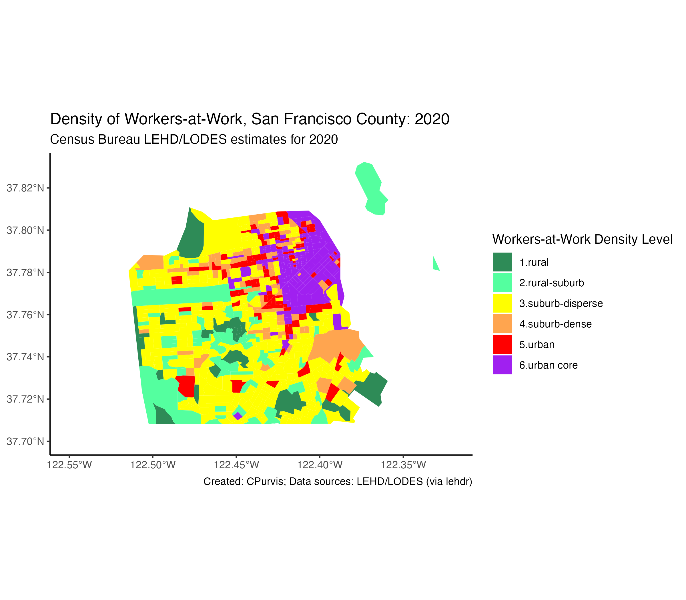
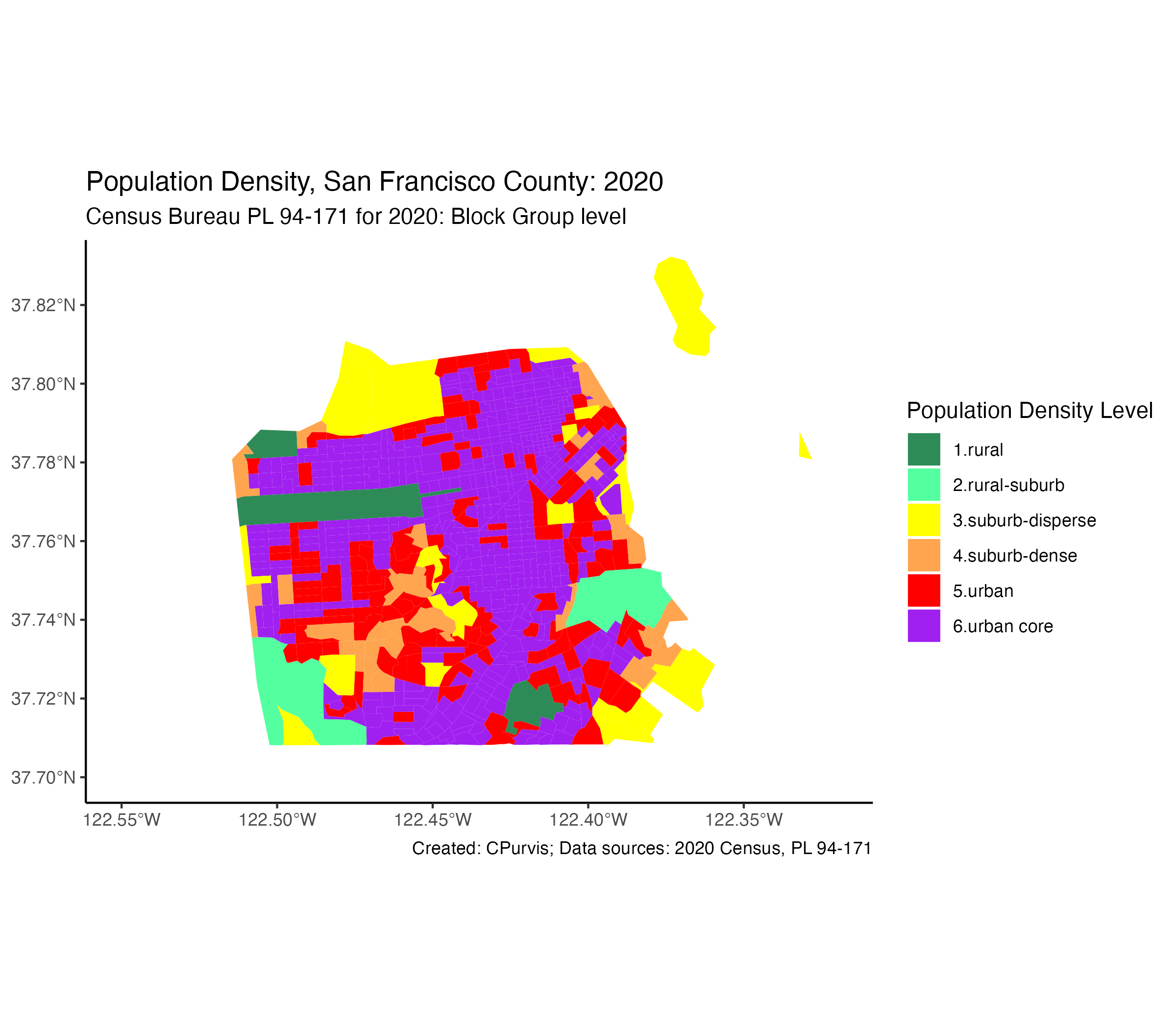
Attached are two maps created using the R package ggplot2. The data is from Census 2020,
PL 94-171 for population density (persons per square mile) and the Census Bureau’s
LEHD/LODES estimates for 2020 (total jobs per square mile).
My six “density categories” are defined as follows:
dplyr::mutate(density_grp = case_when(
jobs_per_sqmi < 500 ~ "1.rural",
jobs_per_sqmi < 1000 ~ "2.rural-suburb",
jobs_per_sqmi < 6000 ~ "3.suburb-disperse",
jobs_per_sqmi < 10000 ~ "4.suburb-dense",
jobs_per_sqmi < 20000 ~ "5.urban",
jobs_per_sqmi >= 20000 ~ "6.urban core",
TRUE ~ "0.missing data”))
“Mutate” sounds horrible, but it’s just the “dplyr” verb for “create a new variable”.
(“dplyr” is a very handy-dandy R package).
Certain block groups in the City of San Francisco have “rural” population density. These
are our parks: Golden Gate Park, Lincoln Park, McLaren Park. The Presidio might be
categorized as a “dispersed suburb”. Most block groups in San Francisco are “urban core”
(greater than 20,000 persons per square mile).
Some block groups in downtown San Francisco are not that heavily populated, such as the
Financial District and Union Square areas. (Of course, vast overwhelming anecdotal
evidence suggests that downtown San Francisco is a ghost town due to the pandemic. Ain’t
necessarily true, of course.)
But the San Francisco financial district could not be considered a “suburb” by any stretch
of the imagination. This is why we should also review data on jobs per square mile (job
density) as a counter measure to simple population density.
My resulting hybrid measure would use the maximum value of population density (total
population per square mile) and job density (jobs per square mile) in determining if a
neighborhood is rural, suburban, or urban. I would use the same density ranges as shown
above.
I could use a compound density measure (e.g., (population + jobs) / land area), but I’m
satisfied with using the maximum of population OR jobs to typify a neighborhood.
(Our San Francisco financial district block group - tract 117.00, block group #3 - bounded
by Bush-Kearny-Sacramento-Drumm-Market, is 0.07984 square miles, with a population of 442
and a job base of 49,634 employees, for a population density of 5,535 persons per square
mile and a job density of 621,613 jobs per square mile. Yes, over 600,000 jobs per square
mile!!)
Hope this is of interest.
Chuck Purvis,
Hayward, California

18 May
18 May
3:54 p.m.
Once again valuable work you are doing.
I’ve been playing around with using AI (ChatGPT, Bard) to create Python code. The AI
helped structure the code. Iwas wondering if you’ve given AI a shot for ‘R’?
[cid:image001.png@01D98987.F0D7B900]
559/224-7388: Landline (not answered unless I know the number)
559/355-1678: cell
Due to the current health emergency, Caltrans' Planning & Local Assistance staff
are working remotely whenever possible. While there may be some delay in our response
times, we continue to be available via email and remain committed to customer service.
From: Charles Purvis <clpurvis(a)att.net>
Sent: Thursday, May 18, 2023 12:06 PM
To: The Census Transportation Products Program Community of Practice/Users discussion and
news list <ctpp(a)listserv.transportation.org>
Subject: [CTPP News] Comparison maps for San Francisco City: Population Density (PL94171)
and Job Density(LEHD)
EXTERNAL EMAIL. Links/attachments may not be safe.
Attached are two maps created using the R package ggplot2. The data is from Census 2020,
PL 94-171 for population density (persons per square mile) and the Census Bureau’s
LEHD/LODES estimates for 2020 (total jobs per square mile).
My six “density categories” are defined as follows:
dplyr::mutate(density_grp = case_when(
jobs_per_sqmi < 500 ~ "1.rural",
jobs_per_sqmi < 1000 ~ "2.rural-suburb",
jobs_per_sqmi < 6000 ~ "3.suburb-disperse",
jobs_per_sqmi < 10000 ~ "4.suburb-dense",
jobs_per_sqmi < 20000 ~ "5.urban",
jobs_per_sqmi >= 20000 ~ "6.urban core",
TRUE ~ "0.missing data”))
“Mutate” sounds horrible, but it’s just the “dplyr” verb for “create a new variable”.
(“dplyr” is a very handy-dandy R package).
Certain block groups in the City of San Francisco have “rural” population density. These
are our parks: Golden Gate Park, Lincoln Park, McLaren Park. The Presidio might be
categorized as a “dispersed suburb”. Most block groups in San Francisco are “urban core”
(greater than 20,000 persons per square mile).
Some block groups in downtown San Francisco are not that heavily populated, such as the
Financial District and Union Square areas. (Of course, vast overwhelming anecdotal
evidence suggests that downtown San Francisco is a ghost town due to the pandemic. Ain’t
necessarily true, of course.)
But the San Francisco financial district could not be considered a “suburb” by any stretch
of the imagination. This is why we should also review data on jobs per square mile (job
density) as a counter measure to simple population density.
My resulting hybrid measure would use the maximum value of population density (total
population per square mile) and job density (jobs per square mile) in determining if a
neighborhood is rural, suburban, or urban. I would use the same density ranges as shown
above.
I could use a compound density measure (e.g., (population + jobs) / land area), but I’m
satisfied with using the maximum of population OR jobs to typify a neighborhood.
(Our San Francisco financial district block group - tract 117.00, block group #3 - bounded
by Bush-Kearny-Sacramento-Drumm-Market, is 0.07984 square miles, with a population of 442
and a job base of 49,634 employees, for a population density of 5,535 persons per square
mile and a job density of 621,613 jobs per square mile. Yes, over 600,000 jobs per square
mile!!)
Hope this is of interest.
Chuck Purvis,
Hayward, California
[cid:image002.png@01D98987.F0D7B900]
[cid:image003.png@01D98987.F0D7B900]
_______________________________________________
CTPP mailing list --
ctpp@listserv.transportation.org<mailto:ctpp@listserv.transportation.org>
To unsubscribe send an email to
ctpp-leave@listserv.transportation.org<mailto:ctpp-leave@listserv.transportation.org>
4:42 p.m.
Hi David:
Regarding Artificial Intelligence, I’ve seen some tweets from Prof Kyle Walker of TCU, the
creator of the r-package tidycensus, but he too was just in early stages of
experimentation. Definitely follow him on twitter and watch the youtube videos he’s
featured in.
As to my retirement: I’m totally retired. I’m finally 65, so I’m a certified senior
citizen / old age pensioner. Working with census data is just a hobby. It keeps my mind
busy, and I’m off the streets and staying out of seedy bars.
I did work as a retired annuitant with MTC for a couple of years in 2013-15, focusing on
the then new statewide household travel survey, working on trip chaining procedures in
SAS; multi-dimensional raking of household weights; and multiple imputation for missing
values. But that’s all over and done.
There are pros and cons of using LEHD/LODES, as discussed in that NCHRP report, though I’m
unawares of any update to that report since 2011.
One of my concerns with LEHD is that the commuter flows may treat an at-home worker with a
regular work address (the work address they would’ve commuted to if there wasn’t the
pandemic!) as a flow from that worker’s home block to their work address block. For
example, if my colleague at MTC has a regular work address of 375 Beale Street, San
Francisco, the LEHD would link his home address with his work address, regardless of
whether he’s making the commute, or working-at-home. (I may need to re-write this
paragraph.)
Hope all is well!!
Chuck
On May 18, 2023, at 12:54 PM, Berggren, David M@DOT
<david.berggren(a)dot.ca.gov> wrote:
Once again valuable work you are doing.
I’ve been playing around with using AI (ChatGPT, Bard) to create Python code. The AI
helped structure the code. Iwas wondering if you’ve given AI a shot for ‘R’?
<image001.png>
559/224-7388: Landline (not answered unless I know the number)
559/355-1678: cell
Due to the current health emergency, Caltrans' Planning & Local Assistance staff
are working remotely whenever possible. While there may be some delay in our response
times, we continue to be available via email and remain committed to customer service.
From: Charles Purvis <clpurvis(a)att.net <mailto:clpurvis@att.net>>
Sent: Thursday, May 18, 2023 12:06 PM
To: The Census Transportation Products Program Community of Practice/Users discussion and
news list <ctpp(a)listserv.transportation.org
<mailto:ctpp@listserv.transportation.org>>
Subject: [CTPP News] Comparison maps for San Francisco City: Population Density (PL94171)
and Job Density(LEHD)
EXTERNAL EMAIL. Links/attachments may not be safe.
Attached are two maps created using the R package ggplot2. The data is from Census 2020,
PL 94-171 for population density (persons per square mile) and the Census Bureau’s
LEHD/LODES estimates for 2020 (total jobs per square mile).
My six “density categories” are defined as follows:
dplyr::mutate(density_grp = case_when(
jobs_per_sqmi < 500 ~ "1.rural",
jobs_per_sqmi < 1000 ~ "2.rural-suburb",
jobs_per_sqmi < 6000 ~ "3.suburb-disperse",
jobs_per_sqmi < 10000 ~ "4.suburb-dense",
jobs_per_sqmi < 20000 ~ "5.urban",
jobs_per_sqmi >= 20000 ~ "6.urban core",
TRUE ~ "0.missing data”))
“Mutate” sounds horrible, but it’s just the “dplyr” verb for “create a new variable”.
(“dplyr” is a very handy-dandy R package).
Certain block groups in the City of San Francisco have “rural” population density. These
are our parks: Golden Gate Park, Lincoln Park, McLaren Park. The Presidio might be
categorized as a “dispersed suburb”. Most block groups in San Francisco are “urban core”
(greater than 20,000 persons per square mile).
Some block groups in downtown San Francisco are not that heavily populated, such as the
Financial District and Union Square areas. (Of course, vast overwhelming anecdotal
evidence suggests that downtown San Francisco is a ghost town due to the pandemic. Ain’t
necessarily true, of course.)
But the San Francisco financial district could not be considered a “suburb” by any
stretch of the imagination. This is why we should also review data on jobs per square mile
(job density) as a counter measure to simple population density.
My resulting hybrid measure would use the maximum value of population density (total
population per square mile) and job density (jobs per square mile) in determining if a
neighborhood is rural, suburban, or urban. I would use the same density ranges as shown
above.
I could use a compound density measure (e.g., (population + jobs) / land area), but I’m
satisfied with using the maximum of population OR jobs to typify a neighborhood.
(Our San Francisco financial district block group - tract 117.00, block group #3 -
bounded by Bush-Kearny-Sacramento-Drumm-Market, is 0.07984 square miles, with a population
of 442 and a job base of 49,634 employees, for a population density of 5,535 persons per
square mile and a job density of 621,613 jobs per square mile. Yes, over 600,000 jobs per
square mile!!)
Hope this is of interest.
Chuck Purvis,
Hayward, California
<image002.png>
<image003.png>
_______________________________________________
CTPP mailing list -- ctpp(a)listserv.transportation.org
<mailto:ctpp@listserv.transportation.org>
To unsubscribe send an email to ctpp-leave(a)listserv.transportation.org
<mailto:ctpp-leave@listserv.transportation.org>_______________________________________________
CTPP mailing list -- ctpp(a)listserv.transportation.org
<mailto:ctpp@listserv.transportation.org>
To unsubscribe send an email to ctpp-leave(a)listserv.transportation.org
<mailto:ctpp-leave@listserv.transportation.org>
4:47 p.m.
Don’t you miss the “seedy bars”?
I’m going to check further. I thought I saw something from the census about updated LEHD
data.
It’s great to hear from you, and that you are enjoying your retirement.
[cid:image001.png@01D9898F.499F8520]
559/224-7388: Landline (not answered unless I know the number)
559/355-1678: cell
Due to the current health emergency, Caltrans' Planning & Local Assistance staff
are working remotely whenever possible. While there may be some delay in our response
times, we continue to be available via email and remain committed to customer service.
From: Charles Purvis <clpurvis(a)att.net>
Sent: Thursday, May 18, 2023 1:43 PM
To: The Census Transportation Products Program Community of Practice/Users discussion and
news list <ctpp(a)listserv.transportation.org>
Subject: [CTPP News] Re: Comparison maps for San Francisco City: Population Density
(PL94171) and Job Density(LEHD)
EXTERNAL EMAIL. Links/attachments may not be safe.
Hi David:
Regarding Artificial Intelligence, I’ve seen some tweets from Prof Kyle Walker of TCU, the
creator of the r-package tidycensus, but he too was just in early stages of
experimentation. Definitely follow him on twitter and watch the youtube videos he’s
featured in.
As to my retirement: I’m totally retired. I’m finally 65, so I’m a certified senior
citizen / old age pensioner. Working with census data is just a hobby. It keeps my mind
busy, and I’m off the streets and staying out of seedy bars.
I did work as a retired annuitant with MTC for a couple of years in 2013-15, focusing on
the then new statewide household travel survey, working on trip chaining procedures in
SAS; multi-dimensional raking of household weights; and multiple imputation for missing
values. But that’s all over and done.
There are pros and cons of using LEHD/LODES, as discussed in that NCHRP report, though I’m
unawares of any update to that report since 2011.
One of my concerns with LEHD is that the commuter flows may treat an at-home worker with a
regular work address (the work address they would’ve commuted to if there wasn’t the
pandemic!) as a flow from that worker’s home block to their work address block. For
example, if my colleague at MTC has a regular work address of 375 Beale Street, San
Francisco, the LEHD would link his home address with his work address, regardless of
whether he’s making the commute, or working-at-home. (I may need to re-write this
paragraph.)
Hope all is well!!
Chuck
On May 18, 2023, at 12:54 PM, Berggren, David M@DOT
<david.berggren@dot.ca.gov<mailto:david.berggren@dot.ca.gov>> wrote:
Once again valuable work you are doing.
I’ve been playing around with using AI (ChatGPT, Bard) to create Python code. The AI
helped structure the code. Iwas wondering if you’ve given AI a shot for ‘R’?
<image001.png>
559/224-7388: Landline (not answered unless I know the number)
559/355-1678: cell
Due to the current health emergency, Caltrans' Planning & Local Assistance staff
are working remotely whenever possible. While there may be some delay in our response
times, we continue to be available via email and remain committed to customer service.
From: Charles Purvis <clpurvis@att.net<mailto:clpurvis@att.net>>
Sent: Thursday, May 18, 2023 12:06 PM
To: The Census Transportation Products Program Community of Practice/Users discussion and
news list
<ctpp@listserv.transportation.org<mailto:ctpp@listserv.transportation.org>>
Subject: [CTPP News] Comparison maps for San Francisco City: Population Density (PL94171)
and Job Density(LEHD)
EXTERNAL EMAIL. Links/attachments may not be safe.
Attached are two maps created using the R package ggplot2. The data is from Census 2020,
PL 94-171 for population density (persons per square mile) and the Census Bureau’s
LEHD/LODES estimates for 2020 (total jobs per square mile).
My six “density categories” are defined as follows:
dplyr::mutate(density_grp = case_when(
jobs_per_sqmi < 500 ~ "1.rural",
jobs_per_sqmi < 1000 ~ "2.rural-suburb",
jobs_per_sqmi < 6000 ~ "3.suburb-disperse",
jobs_per_sqmi < 10000 ~ "4.suburb-dense",
jobs_per_sqmi < 20000 ~ "5.urban",
jobs_per_sqmi >= 20000 ~ "6.urban core",
TRUE ~ "0.missing data”))
“Mutate” sounds horrible, but it’s just the “dplyr” verb for “create a new variable”.
(“dplyr” is a very handy-dandy R package).
Certain block groups in the City of San Francisco have “rural” population density. These
are our parks: Golden Gate Park, Lincoln Park, McLaren Park. The Presidio might be
categorized as a “dispersed suburb”. Most block groups in San Francisco are “urban core”
(greater than 20,000 persons per square mile).
Some block groups in downtown San Francisco are not that heavily populated, such as the
Financial District and Union Square areas. (Of course, vast overwhelming anecdotal
evidence suggests that downtown San Francisco is a ghost town due to the pandemic. Ain’t
necessarily true, of course.)
But the San Francisco financial district could not be considered a “suburb” by any stretch
of the imagination. This is why we should also review data on jobs per square mile (job
density) as a counter measure to simple population density.
My resulting hybrid measure would use the maximum value of population density (total
population per square mile) and job density (jobs per square mile) in determining if a
neighborhood is rural, suburban, or urban. I would use the same density ranges as shown
above.
I could use a compound density measure (e.g., (population + jobs) / land area), but I’m
satisfied with using the maximum of population OR jobs to typify a neighborhood.
(Our San Francisco financial district block group - tract 117.00, block group #3 - bounded
by Bush-Kearny-Sacramento-Drumm-Market, is 0.07984 square miles, with a population of 442
and a job base of 49,634 employees, for a population density of 5,535 persons per square
mile and a job density of 621,613 jobs per square mile. Yes, over 600,000 jobs per square
mile!!)
Hope this is of interest.
Chuck Purvis,
Hayward, California
<image002.png>
<image003.png>
_______________________________________________
CTPP mailing list --
ctpp@listserv.transportation.org<mailto:ctpp@listserv.transportation.org>
To unsubscribe send an email to
ctpp-leave@listserv.transportation.org<mailto:ctpp-leave@listserv.transportation.org>
_______________________________________________
CTPP mailing list --
ctpp@listserv.transportation.org<mailto:ctpp@listserv.transportation.org>
To unsubscribe send an email to
ctpp-leave@listserv.transportation.org<mailto:ctpp-leave@listserv.transportation.org>
872
days inactive
872
days old
ctpp@listserv.transportation.org
3 comments
2 participants
participants (2)
-
 Berggren, David M@DOT
 -
 Charles Purvis